You’re not sure whether you should buy a drone and do it in-house or whether you should outsource the work to a drone services company?
You know that you can work more safely and cost-effectively by using drones but don’t know how to go about it?
Drones aren’t just for Christmas, they are a seriously sophisticated tool for getting work done quickly and safely but you know that already.
Have a look at some of the other posts on this site if you aren’t already sure how drones can help make your business safer and more profitable.
This article will lay out the pros and cons of each approach to help you decide which is best for your situation.
This article is going to give you the information you need to be able to make an informed decision about how you go about introducing drones into your business.
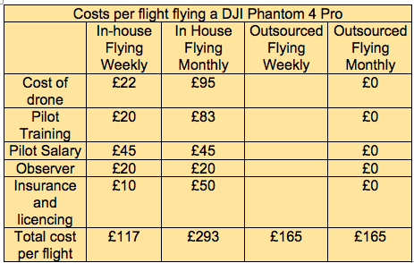
We’re not going to talk here about which drones are best for you, we’ll do that in another post or you can get in touch to have a chat about what would suit your needs best. If after reading this you think buying your own drone is the right thing for your business we will give as much advice as you need. If you want to skip the reading you can go straight to the bottom of the post and have a look. at the table of costs. Remember though that your decision needs to take into account more than just financial costs. The best way forward may be to outsource until you get a feel for what would be required to run your own drone programme.
Cost
The first thing most business owners think about is cost. Cost is, of course, an important driver in making business decisions. We’ll discuss costs first and then address some other things you need to consider.
For illustration purposes, we will suppose that you want to use a drone to carry out building inspection work on a construction site. You want to be able to document the progress on a monthly basis to show to stakeholders and to monitor health and safety on the site.
You may well want to do it more often than that but I am using it for illustration purposes because the latest job we quoted for was for a monthly flight over a road construction site.
Is it going to be more cost effective to do the drone work in-house or to outsource it?
To do it in-house you’re going to need a drone. We will assume that you just need a standard professional drone with a high definition camera. A DJI Phantom 4 Pro is probably going to do you.
The typical costs of a drone suitable for the purpose will be around £2000.
That will get you a Phantom 4 pro with a couple of extra batteries and a case to keep it in. If you want to do anything more specialised then you will start spending lots more. A 30 times zoom camera, for example, will cost £8000 and you’ll need a £8000 drone to hang it on!
Additional Equipment
You are also going to need some other kit some of which you may already have, things like cones to keep people out of the take-off and landing area, two-way radios for the pilot to be able to communicate with the observers (more about the observers later) and perhaps PPE.
If you budget another £200-300 for the extra stuff you should be about right.

The drone, batteries and all the rest of the stuff will need looking after and won’t last forever so you will need to budget for replacing it at some point.
You’re also going to need someone to operate it.
You may have read about autonomous drones but in the UK it’s going to be very difficult to get permission from the Civil Aviation Authority (CAA) to fly one of those!
You’ll need a pilot.
If you’re going to do an inspection once a month perhaps one of your team can do it as another part of their job.
The size of the site will dictate how much time a job will take so you’ll have to find the time in that person’s schedule.
No matter what size your site it’s going to take at least an hour to get the kit, set it up, do a quick flight and put the kit away again. You will also have to complete a dynamic site survey and risk assessment as well as the pre and post flight checks so an hour really is the minimum amount of time.
Someone will have to charge the batteries, complete the paperwork (more on that later) and look after the equipment. That’s probably another hour per flight. So a half-hour flight has now taken two hours or longer. Multiply that by an hourly rate and that will give you an idea of your manpower costs.
You may also need to allocate an observer to assist the pilot during the setup and conduct of the flight.
The observer’s job is to keep an eye out for hazards while the pilot is concentrating on flying the drone. Things like people coming close etc. Now you will have to train the pilot. That’s going to cost around £1000 for him or her to be certified competent. You will need to add to that the cost of releasing him or her for a 4 or 5-day course, accommodation and travel costs perhaps and any specialist training that may be required.
Let’s add it up.
So, to put a figure on it for you we are looking at the costs of equipment and for simplicities sake, we will say it lasts for 2 years before you need to replace it. So the cost of equipment per flight will be something like £95 if flying monthly or about £22 if you fly weekly, though replacement costs may be higher if you fly weekly.
The cost per flight of the pilot will be whatever he or she gets paid. Taking an average of £37,000 for a construction site supervisor that would be around £40-50 per flight plus 3 days training per year divided by 12 to give you a monthly figure of £35.
Throw in an observer for the 30-minute flight and we have a grand total of around £175 per flight if flying monthly and £105 per flight if flying weekly. This difference is because the equipment costs remain much the same no matter how many times you fly. I won’t bother adding in battery replacement and charging costs or replacing propellors etc.
We also need to consider legislation and risk.
If you are only flying the drone for your own business purposes and are not selling the data/footage/images then you are not required to have a Permission for Commercial Operations (PfCO) from the CAA.
However, in order to comply with regulations, you will have to operate the drone safely and best practice would be to compile an operations manual in exactly the same way as a PfCO holder would.
To make sure the manual is fit for purpose and will stand up to scrutiny should an accident occur it would be wise to submit it to the CAA as an application for a PfCO.
Production of the manual will take some effort and time but the cost of the PfCO is only £173 in the first year and £130 for annual renewal, though these prices will change in April 2018. Just when you thought that was it covered, you are going to need some insurance.

Insurance.
You won’t be able to get insurance if you don’t have a PfCO and if you are going to get a PfCO you will need insurance. I know it sounds like a catch 22 situation but it works out OK.
‘We already have plenty of insurance‘ I hear you cry but the problem is that for flying drones it must comply with EC Regulation EC 785/2004 and I am pretty sure that the insurance you have doesn’t.
Depending on which drone you fly and what equipment you have for it, insurance can cost anywhere from £400 and up. If you are just flying one drone and associated equipment £400 should cover it. Insurance and PfCO then will add around £50 to your monthly flight making it at least £225.
So that just about covers the cost of doing-it-yourself with a standard professional drone. If you need to use specialist equipment it will be much more than that.
What about getting someone in to do it for you?
Costs will obviously vary between operators but so we are comparing like with like Bird’s Eye Drones would be able to do the same monthly flight and provide you with video and photographs for £165. So if you are flying weekly it would be cheaper to do it yourself but more cost effective to hire someone in to do it monthly. Cost isn’t the only consideration though.
Probably most importantly we will take away work and the risk associated with flying drones.
What else does contracting out give you?
-
It gives you a qualified, insured, licenced and experienced operator who is flying drones for a living and not just once in a while.
-
That means you have a much lower risk of an accident happening on your site and it if it does happen, the drone service provider is responsible.
-
We can use more expensive specialist equipment without you needing to make any investment in it.
-
You won’t have to produce operations manuals, keep your PfCO up to date, provide insurance, look after the equipment or any of the things previously mentioned.
-
We can add value by providing you with data such as photogrammetry and 3d models etc, though this would cost more of course.
-
You hire a turnkey solution and get your data/images/footage provided in a format you can use to get on with your main job.
 By now you should have an idea of whether you should outsource or keep your drone services in-house.
If you still need some more information to help you decide please get in touch with us. We will give you honest advice to help you decide.
We don’t sell drones, only drone services so we will give you impartial information to help you decide the best drone for your needs.
If you have decided that offsetting the risk to someone else is the way forward just get in touch and we can discuss your needs.
You will find other articles to help you understand just how much drones can do for your business in our blogs.


 The following is an article from Historic England describing how they use drone technology to manage their buildings, archaeological sites and landscapes. The original can be found on their


